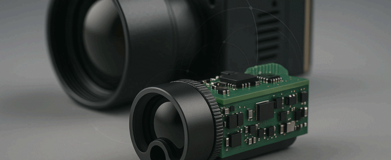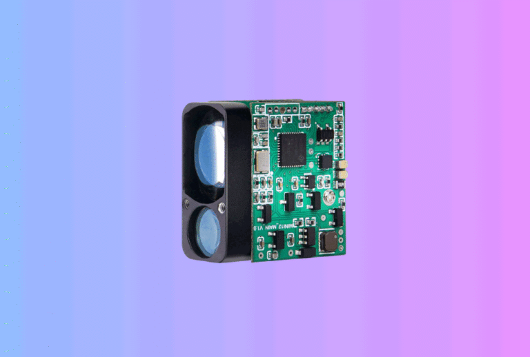
When people think about surveying tools, they often picture a yellow total station on a tripod or a simple handheld distance meter on a construction site. Behind both of these products, however, there is usually the same core component: a laser rangefinder module.
Table of Contents
ToggleFor OEM brands and instrument makers, treating the module as a reusable building block instead of a one-off component can simplify product families, shorten development cycles and open new “smart” workflows that connect the jobsite to cloud project management systems.
This article looks at how to use laser rangefinder modules in modern surveying tools—from handheld meters to bolt-on range heads for total stations—and what you should consider when combining them with tilt sensors, Bluetooth apps and cloud software. It is written from the viewpoint of a China-based OEM manufacturer supplying configurable laser rangefinder modules and supporting complete OEM/ODM solutions.
1. Where laser rangefinder modules fit in modern surveying tools
A classic tape measure gave only line distance. Today’s instruments add much more context: angles, coordinates, elevations and digital records. But in almost all cases the distance backbone is still the laser.
In handheld meters, the module provides quick point-to-point measurements that are combined with tilt reading to calculate heights, horizontal distances and areas. On rotating lasers and layout tools, the module may be used for calibration or for checking reference distances to walls and columns.
In high-end instruments, such as reflectorless total stations or add-on range heads, the same principle applies, but over longer ranges and with stricter accuracy expectations. The difference is less about physics and more about optics, packaging and how the data is fused with angles and coordinates.
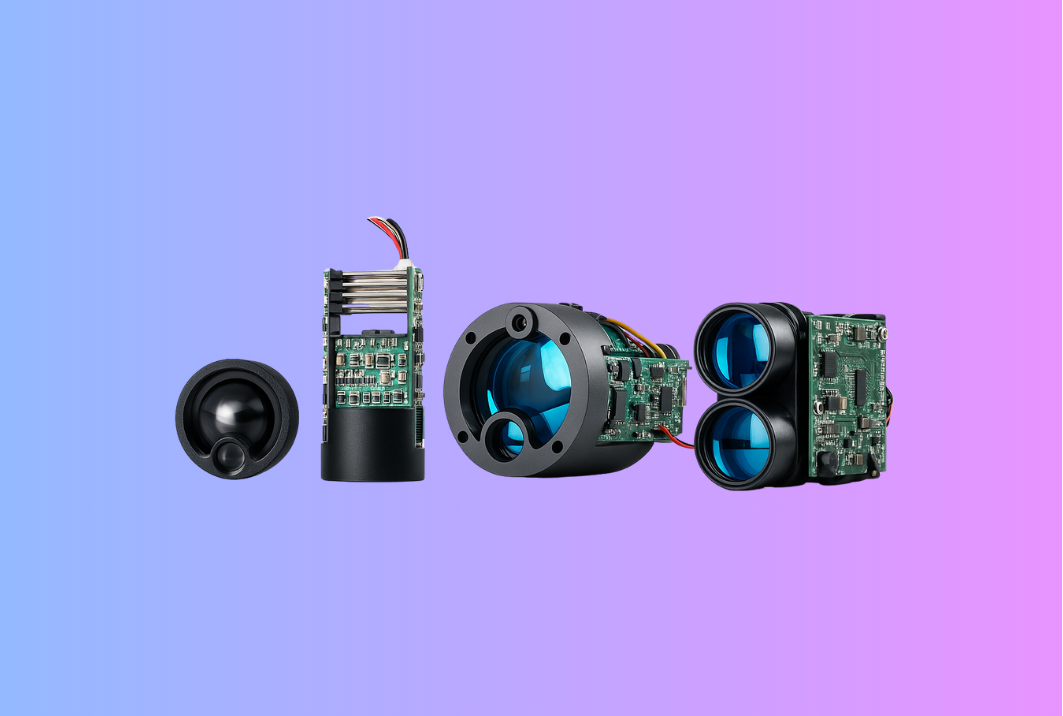
If you standardise on a flexible module platform and combine it with application-specific optics and mechanics, you can cover all of these segments with a consistent technology stack. That is exactly the idea behind Gemin Optics’ OEM-ready laser rangefinder module family.
2. Segment overview: handheld meters vs. add-ons
It helps to divide surveying tools into a few typical product types. The table below shows how requirements usually differ.
| Segment | Typical User | Typical Range | Accuracy Expectation | Key Design Focus |
|---|---|---|---|---|
| Basic handheld distance meter | Tradespeople, DIY | 0.05–60 m | ±2 mm to ±3 mm | Low power, cost, simple UI |
| Smart handheld / app-connected meter | Contractors, site managers | 0.05–100 m | ±1.5 mm to ±2 mm | Bluetooth, data logging, tilt functions |
| Outdoor distance tools (site layout, facade) | Survey assistants, facade installers | 0.1–200 m+ | ±1.5 mm | Bright display, targeting optics, sunlight performance |
| Total station add-on / reflectorless head | Surveyors, civil engineers | 0.5–1,000 m+ (to prisms or walls) | mm-level, repeatable | Optics, alignment, temperature control, interfaces |
Each column pushes the module in a slightly different direction: more or less range, tighter accuracy, different mechanical forms, or more sophisticated interfaces. But a well-designed core can serve all of them.
3. Core performance basics for surveying-grade modules
For surveying tools, accuracy and repeatability matter more than headline distance. A module that claims 1,000 m on a white target but drifts several millimetres as temperature changes will not satisfy professional users, even in short-range meters.
When you evaluate a module for surveying use, pay attention to three axes.
Measurement quality. Look for detailed specifications on error over range, not just a single “±2 mm” statement. Good vendors will show how error behaves at short and long distances, on different reflectivities. Consistency shot-to-shot is just as important as absolute accuracy, because your firmware can compensate for small systematic offsets.
Stability over temperature. Construction sites don’t live in lab conditions. Instruments go from air-conditioned offices to hot roofs or cold mornings. Modules intended for surveying tools should include temperature compensation and calibration to keep drift controlled across the working range.
Close-range behavior. Many rangefinders struggle very close to the instrument because of internal reflections and timing constraints. If your product must measure down to 5 cm or 10 cm, make sure the module has been designed and tested for such distances, not only for “a few metres and beyond.”
In Gemin’s own module lines, for example, the same ToF core used in outdoor golf rangefinder modules is derated and recalibrated for surveying use, where repeatability and temperature stability outweigh raw long-range power.
4. Working with tilt sensors and angle measurement
Most “smart” distance meters marketed today promise more than just length; they calculate areas, volumes and heights. Much of that magic comes from combining range data with tilt or angle sensor readings.
A typical workflow looks like this:
- the laser rangefinder module provides the line distance to a point;
- a 2-axis tilt sensor measures instrument orientation relative to gravity;
- the onboard MCU projects that line into horizontal and vertical components.
From a design perspective, this means the module cannot live in isolation. The mechanical layout must keep the range axis and tilt reference aligned, and the firmware must timestamp and fuse readings correctly.
For total-station add-ons, the same idea extends one step further: the range module is aligned to the instrument’s optical axis and to its precision angle encoders. Any residual offsets or collimation errors must be characterised and compensated in calibration routines.
This is why many OEMs prefer to treat the laser rangefinder module as part of a measurement “head” that includes mechanics and tilt, rather than a loose PCB. It simplifies calibration and improves long-term serviceability, because the whole head can be tested and adjusted as one system.
5. Interfaces: from simple UART to smart Bluetooth apps
At the low end, a distance meter may simply display a number and store the latest result. As you climb the value ladder, data starts to flow outward—to smartphone apps, tablets and cloud services.
On the inside, the module itself usually speaks UART or SPI to an application MCU. On the outside, your product may expose:
- USB for firmware updates and batch data transfer;
- Bluetooth Low Energy for live streaming into mobile apps;
- sometimes Wi-Fi for jobsite router or tablet connections.
The important part is separating concerns. The module should present a clean measurement protocol (distance, error flags, signal quality). The application layer wraps that into higher-level constructs: points, lines, rooms, tasks and project IDs.
Well-documented modules, such as those described in Gemin’s OEM laser rangefinder guide, simplify this. They provide clear commands for triggering, configuration and status, freeing your firmware team to focus on app logic rather than reverse-engineering a black box.
6. Designing handheld surveying meters around a module
In a compact handheld meter, mechanical constraints and power budget can be tighter than the optics themselves. A practical design flow usually goes like this:
First, define the target segment: interior fit-out, general construction, facade work, or semi-professional surveying. Each segment implies different priorities: some care about long range outdoors; others care more about small-room agility and Bluetooth connectivity.
Second, select or adapt a module with matching range and power characteristics. Many OEM customers ask for versions tuned around 80–100 m, which is enough for typical building sites while keeping current draw manageable. Derating the maximum range also reduces eye-safety complexity, since you can meet IEC Class 2 or Class 1 requirements more easily.
Third, integrate the module into a housing that supports ergonomics and targeting. That means:
- keeping the laser aperture and viewfinder/optical sight as close as possible to minimise parallax;
- ensuring enough structural rigidity so shocks don’t gradually misalign the module;
- providing mechanical features for calibration fixtures during production and service.
Finally, add the “smart” layer: a tilt module, a simple UI and connectivity. A Bluetooth-enabled meter that can shoot dimensions directly into a CAD app or cloud project tool becomes much more than a rangefinder; it becomes a data collection device for the whole trades workflow.
7. Add-on range heads for total stations and construction robots
At the high end, some OEMs require range modules that integrate with existing surveying instruments rather than replacing them. Typical examples include add-on heads that sit on a total station, or measurement modules for construction layout robots.
Here the emphasis shifts toward:
- higher maximum range and better energy management per pulse;
- improved optics for small spot size at long distance;
- robust mechanical interfaces to the host instrument.
Because total stations already contain precise angle encoders and advanced controllers, your range head is often treated as a peripheral: it must accept trigger commands, return distances with timestamps, and support calibration sequences.
In such cases, OEM projects often bundle the laser rangefinder module with custom optics, mechanical mounting and alignment services. A platform manufacturer with both module and mechanics experience—as is common in Gemin’s OEM/ODM projects—can design this as a single unit and share alignment and calibration procedures with the instrument maker’s in-house team.
8. Data logging and cloud workflows
Surveying is increasingly about data traceability rather than one-off readings. Contractors and owners want to know who measured what, when, and how those measurements changed over time.
A module-centric architecture fits well with this trend. Because every measurement event already passes through firmware, it is straightforward to attach:
- a timestamp from the meter’s clock or the connected smartphone;
- project and location tags selected in the app;
- operator ID and instrument configuration (range mode, averaging, filters).
The instrument can then synchronise logs over Bluetooth or Wi-Fi to a cloud service. A simple jobsite UI may show only “last 20 measurements,” but the back-end stores full history for quality control and dispute resolution.
In multi-device fleets, you can even cross-compare measurements from different instruments using the same module type. If a batch of meters starts drifting, the pattern appears in the cloud, and you can recall or recalibrate units before serious errors accumulate.
9. Reliability, calibration and after-sales
Surveying tools live hard lives: thrown into trucks, used in rain, left in hot vehicles. Reliability engineering around the module is therefore a core OEM task.
From the module side, this means designing for adequate MTBF and applying derating: operating components below their maximum electrical and thermal limits to extend life. From the instrument side, it means:
- protecting the module with a robust housing and suitable sealing;
- specifying shock and vibration limits that reflect real jobsite use;
- providing users with simple field checks and calibration routines.
Module-level design can also simplify after-sales. If your distance meter or add-on head is built around a standardised, socketed module, service centres can swap modules quickly without complex rework. In some B2B agreements, OEMs even keep spare modules stocked with local partners, reducing turnaround time for high-value customers.
In the golf and hunting world, Gemin has seen brands build successful refurbish and service programmes around modular designs. The same thinking applies to surveying instruments: by planning at module level, you reduce long-term support costs and protect your reputation.
10. Working with a China OEM partner on surveying tools
For many instrument brands, the question is not “buy module or build module,” but “which OEM partner can support our roadmap for the next five to ten years?”
A partner like Gemin Optics, with in-house design of laser rangefinder modules, optics and firmware, can help you:
- select or customise a module platform suitable for your target segment;
- co-design the measurement head that combines module, optics and tilt;
- define and document calibration procedures for your factories and service centres;
- extend the same platform into related products—golf, hunting, industrial—if your brand plays in multiple markets.
Because the modules are also used in other sectors (for example, golf and hunting rangefinders), the underlying components benefit from aggregated demand and more mature supply chains. That helps keep long-term availability stable, which is crucial for survey products with slow refresh cycles.
Conclusion – Building smarter surveying tools on a solid ranging core
Laser rangefinder modules have quietly become the common denominator across many surveying and construction instruments: basic handheld meters, Bluetooth-enabled smart tools, outdoor layout devices and reflectorless range heads.
By treating the module as a stable core and building smart firmware, mechanics and cloud workflows around it, OEMs can:
- shorten time-to-market for new models;
- keep accuracy and reliability under control;
- offer richer data and better integration with modern project-management tools.
If you are planning your next generation of surveying or construction tools and want to explore a reusable module platform, you can start by reviewing Gemin Optics’ laser rangefinder modules and OEM guidance, then discussing your specific range, accuracy and integration needs with the engineering team. A thoughtful module choice today can anchor your handheld and total-station product families for years to come.